By Mary Reid Barrow
The Lynnhaven River is like a bright blue bow on top of the package that’s the city of Virginia Beach.
The river’s bow is tied by a watery blue ribbon that ends up wrapping the city from the Chesapeake Bay to Back Bay and the North Carolina line.
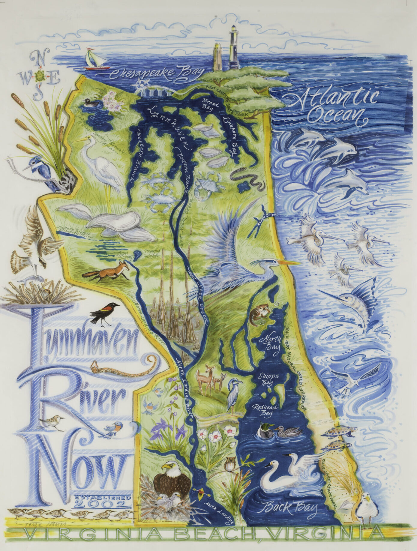
Nowhere is the river’s influence across Virginia Beach more evident than in LRNow’s new map of the Lynnhaven, an accurate and luscious illustration, created by artist Terre Ittner.
“So many people just don’t know about the connectiveness of the river,” Terre said.
There’s nothing she likes better than taking road trips with her dogs round Virginia Beach, exploring neighborhoods and country roads. That is how she discovered the city and the Lynnhaven River are inter-connected from top to bottom.
If you were an expert paddler and had some guidance, you could put your kayak in the water on the shores of the Chesapeake Bay at the river mouth head under the Lesner Bridge on Shore Drive and travel all the way to the North Carolina line, Terre learned.
Look at her map to see where the Lynnhaven flows into West Neck Creek which then flows into the North Landing River which then makes its way to the Norfolk Carolina line and into Currituck Sound.
The lighthouses at Cape Henry where the settlers first landed in 1607 set the scene at the top of the map, a reminder of how far back our roots go.
“This is where it all began,” Terre said.
Your eyes pick up dolphins along the ocean and tundra swan on Back Bay. An eagle, fox and red-winged black bird pop up in the lowlands along the North Landing River, more reminders of not only where we live but who lives with us.
Look at the map as a whole and you get the full picture of the river’s impact but then look closely to see stories that pop up. Her favorite is learning that mountain laurel grows out of its natural range around Lake Lawson/Lake Smith Natural Area and she includes an illustration of one of its flowers.
Keep looking at the map and it becomes abundantly clear how water dominates our city. Not only do the Bay, the ocean and Back Bay bind us with blue ribbon on the north, east and south but the North Landing River also snakes in from the west to head south. Lakes, inlets and creeks pop up like decorations on the package.
You might think you know all this but there is nothing like seeing it to really believe it.
Terre’s map is available for $50 at the LRNow office or online here. It comes rolled in a box which you could wrap in blue to match the blue of the Lynnhaven. It‘s a gift to be hung in the home, a classroom or office, or just unrolled every now and then to get your bearings once again.
Wherever it goes, the map won’t fail to remind you of your roots in this water-wrapped area of ours that we call Virginia Beach.