Location
- Starting at the tip of Cape Henry (Northeast Virginia Beach), it covers all along the Oceanfront down to the North Carolina border.
Size
- 5,500 acres or 5.5 sq miles
- 3% of the city.
Population Density
- The permanent population is small, but grows immensely in the summer with the influx of temporary residents.
Land Use (Urban/Rural)
- Dense commercial use for the tourist industry.
Topography
- Very little elevation gain, except where there are remnants of the old dunes in First Landing State Park (this section of the park is located in the upper 80 streets on ocean side) and where the iconic Cavalier Hotel sits.
- Average elevation: 7ft
Names of Federal and State Properties
- NAS Dam Neck
- Back Bay National Wildlife Refuge
- False Cape State Park
- Fort Story Joint Base
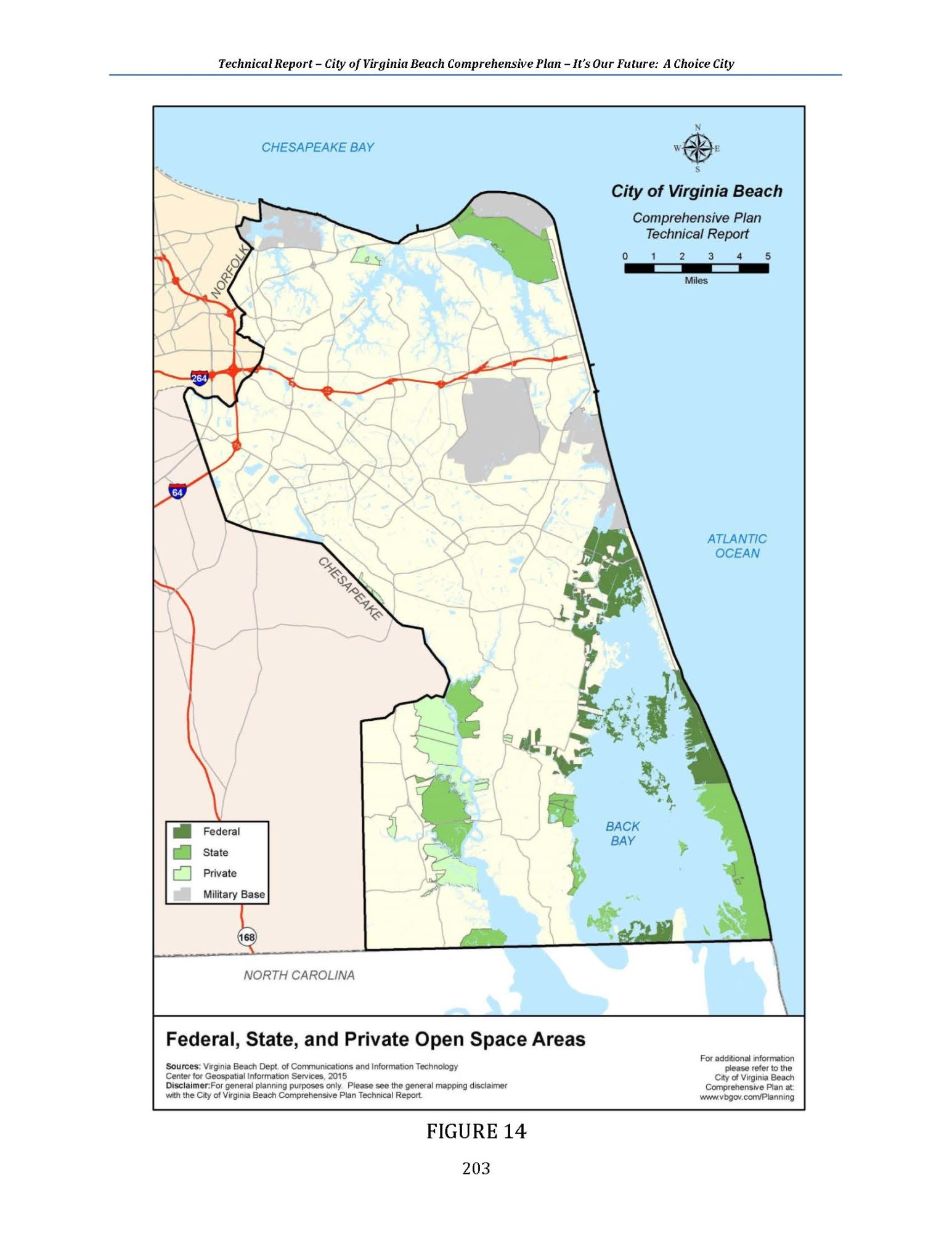
Federal, State, and Private Open Space Areas
Salinity
- 35 parts per million (ppm)
Threats
- Marine Debris/Pollution, sea level rise, beach/shoreline erosion.
- High bacteria levels during the swimming season causing harm to marine life and beach closures (May-September).
Recreation Areas (access points, natural areas, parks)
- Beach Garden Park (City)
- Little Island Park (City)
- False Cape State Park
- Back Bay National Wildlife Refuge (Federal)
Plants of Interest
- Sea oats
- Virginia trumpet vine- Campsis radicans
- Beach pea- Lathyrus japonicus
- Live oak
- ‘Sandspurs’ or ‘sandburs’ are a type of grass that produces many thorny burs. By late summer and autumn, sandspurs become more brittle and are more likely to leave splinters. Majority of burs will lose most of their sharp points by Winter.
Animals of Interest
- Shorebirds: gulls, turns, pelicans, sandpipers, piping clover
- Horseshoe crabs
- Ghost crabs
- Sea turtles
- Whales
- Dolphins
- Sharks
- Other marine life
Other Organisms
- Skate egg cases (mermaid purse)
- Whelk shell eggs
Soil Type
- Sandy soils
- Wet soils (Southern VB)
History
- Late 16th century- The Native Americans of the Chesapeake Indian tribe inhabited the area and were later eradicated by the Powhatan chieftain just prior to English colonization. In the aftermath, the Nansemonds spread from west to east inhabiting this watershed in Virginia Beach.
- April 26, 1607 Jamestown colonists landed at Cape Henry.
- 1634 – Virginia Beach was originally part of the Elizabeth City Shire (one of the eight shires (counties) established by the English Government.
- Eighteenth century – Virginia’s leading cash crop, tobacco, did not grow particularly well in this area. Instead, wheat oats and corn proved to be better cash crops in Virginia Beach.
- In the 1880’s, the Norfolk, Virginia Beach Railroad and Improvement Company decided to create a resort on the Atlantic Ocean shoreline of Princess Anne County. The resort developer constructed the Norfolk, Virginia Beach and Southern Railroad, a narrow gauge line to carry tourists across the county from the steamship docks at Norfolk to the Atlantic Ocean shoreline at what today is the resort area of Virginia Beach. A competitor, the Chesapeake Transit Company built a railroad to Cape Henry that carried both tourists and lumber from the forests of “The Desert.”
- The War of 1812 – British Warship cannons fired inland along the coast. This deemed the entire beachfront area the name Historic Seatack from “Sea Attacks.”
- The first structure built on the resort strip was a wooden clubhouse erected by Colonel Marshall Parks in the 1880s. The resort town continued to grow and was incorporated as the town of Virginia Beach in 1906.
- 1912 – Seaside Park Amusement Complex opened.
- 1916 – Princess Anne Country Club was established.
- 1926 – Concrete boardwalk was built along the Atlantic Ocean beach.
- 1927 – Construction of the Cavalier Hotel along with several hunt clubs.
- The Fleet Air Defense Training Center, currently the military facility at Dam Neck, was first organized as an anti-aircraft school during WWII.
- 1963 – 1988: Rapid population growth in the resort area. A new boardwalk and seawall were constructed during this period.
- Virginia Beach Surf and Rescue Museum: 1878 – Originally established as the United States Life Saving Service Organization. In 1915 it merged and became the United States Coast Guard Station, Station#162
Do you live in the Ocean Coastal Watershed? Order your FREE sticker today! Email Office@LRNow.org
Don’t know which watershed you live in? Click HERE to discover your watershed.