Location
- Southwestern portion of Virginia Beach.
- Begins in the heart of Kempsville, a highly developed area.
- Water flows in a southeasterly direction though the cities of Virginia Beach (on the east) and Chesapeake (on the west), emptying into the Albemarle-Pamlico Sounds and ultimately the Atlantic Ocean.
- A vital link in the Intercoastal Waterway.
- Dept of Conservation and Historic Resources (1987) – The North Landing Scenic River System.
Size (shoreline and acreage drained)
- 62,965 acres
- Covering 32.1% of the city of Virginia Beach.
- City of VB Comprehensive Plan (2016) page 112
Population Density
- Lowest population density in all of Virginia Beach with urban and suburban development in the northern portion.
Land Use (urban/rural)
- A mix of agricultural, waterfront, commercial, residential and public developments.
- Much of the land in the southern part of the watershed is rural and contains farms averaging 200 acres or less.
- The North Landing River Watershed encompasses an area of 74,635 acres with 2,841 of these acres located in open waters.
- Agriculture is the primary land use in the watershed, occupying 45% of the land, or 32,633 acres.
- Residential uses, commercial buildings, and roadways cover another 12,997 acres of the basin or 18% of the land area.
- The remaining 26,164 acres are undeveloped.
Topography
- Flat topography and high shallow water tables
- The physiography of the area consists of narrow, subdued, well drained ridges; broad, poorly drained flats; and coastal area.
Property owned owned by city, state, federal & nonprofit
- Nonprofit :The Nature Conservancy and the commonwealth of Virginia (DCR) owns and manages more than ten thousand acres.
- Local: The City of Virginia Beach purchased a 1,422 acre property known as Stumpy Lake in 2001 from the City of Norfolk.
- State: Department of Conservation and Recreation (DCR) owns 3,441 Acres.
- Federal: United States Navy % n/a
Names of Federal or State properties
- North Landing River Natural Area Preserve *This preserve remains closed to public access due to staffing shortfalls.
- Naval Station Oceana
Major Bodies of water and salinity
- North Landing River: Brackish – The Pocaty River, Blackwater Creek, West Neck Creek are separate stretches of the North Landing River System.
- Stumpy Lake: Freshwater; part of our regional freshwater water supply system for Norfolk.
- Intercoastal Waterway: Brackish
- West Neck Creek: Brackish
- High salinity below Munden Point.
*Wind driven tides affect salinity.
Tides
- Wind driven: winds blowing from the east push sea water through the Currituck Inlet and farther northward causing irregular water level fluctuations on the North Landing River (DCR,n.d.).
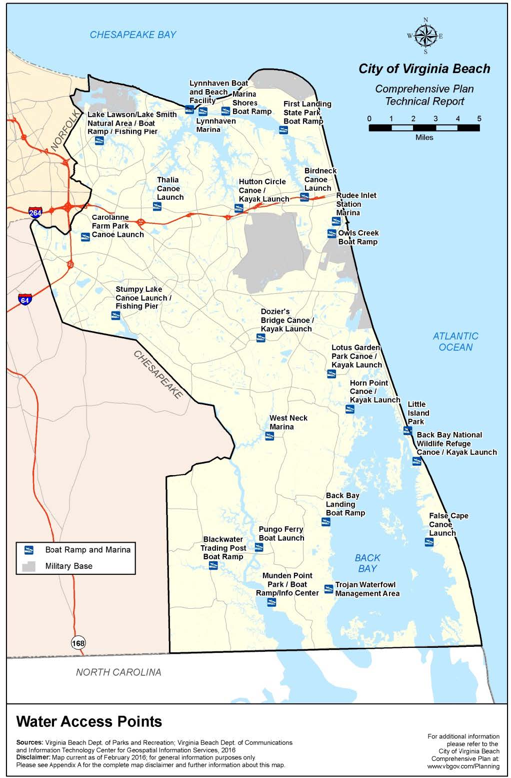
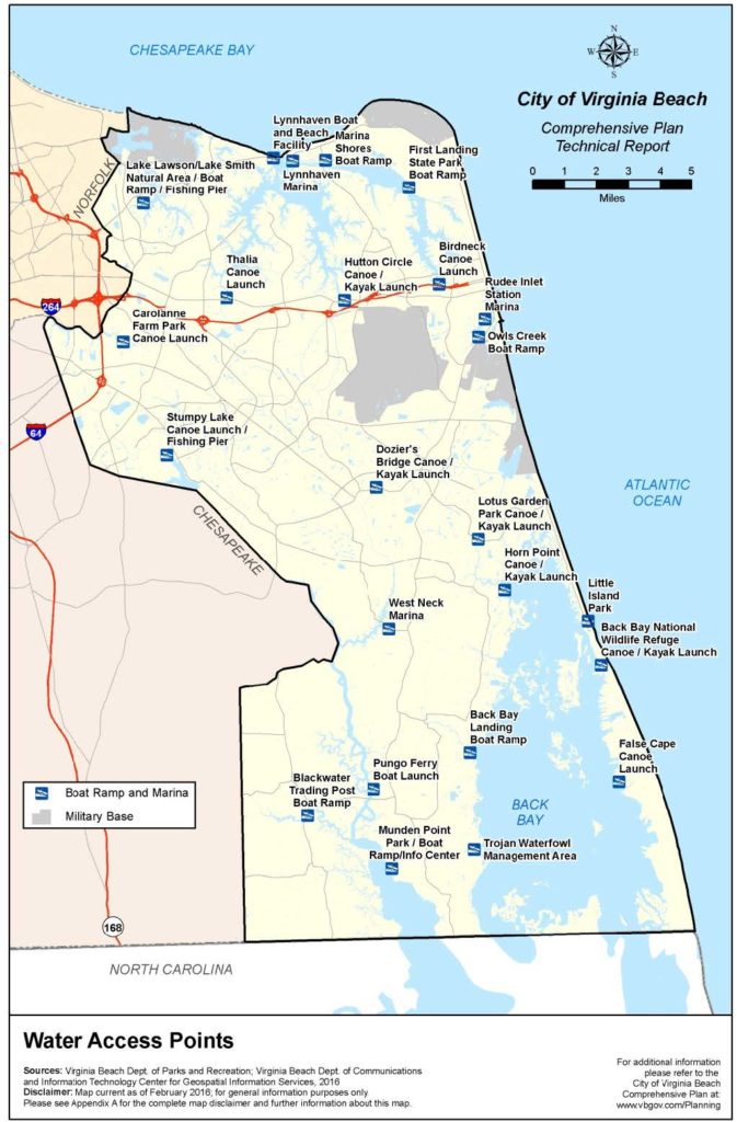
Recreation Areas (access points, natural areas, parks)
- Stumpy Lake Canoe /Kayak Launch:4797 Indian River Road; Designed for non-motorized Vessels; ADA Compliant
- Munden Point Park: 2001 Pefley Lane, Virginia Beach;100-acre park located at the leg of the intercoastal waterway
- Pungo Ferry Landing Park/ Boat Launch: 2272 Old Pungo Ferry Rd; 20-acre park; Boat ramp-no launch fees; soft canoe/kayak launch (approx 30-yards from parking to launch area); fishing area-freshwater license required.
- Blackwater Trading Post Boat Ramp: 5605 Blackwater Rd, Virginia Beach, VA; Fuel Station, Boat Launch ($4 launch fee) & Convenience Store.
Other/ Fun Facts
- Stumpy Lake: In 1910, Norfolk dammed off a section of the North Landing River watershed called Gum Springs Swamp to create the lake as part of its water supply. The shallow lake got its name from the stumps of cypress and tupelo trees which are visible when the water is low.
- Barrow, 1999, The Virginian Pilot p. B9
Plants
- Dense understory of evergreen shrubs including inkberry, wax myrtle, blue pickerelweed fetterbrush
- Trees such as pond pine, Atlantic white cedar, red bay, sweetbay occur as scattered individuals scattered through the shrub bog.
- Hardwood forest, pinewood forest, black gum, tupelo, cypress.
- Vines, grasses and other: greenbrier, sawgrass, butterfly milkweed, the Carolina lileopsis.
- Uncommon Wealth, page 188
- Messina, D. A Jewel of Nature; The Beacon
Wetlands
- Estuarine/Marine wetlands and freshwater forested shrub wetland
- Cypress/tupelo swamp
- Freshwater marshes
- Forested swamps
- Pocosins
- Pocosins are peat bogs where unusual plants grow, including the pink spreading pogonia.
- Uncommon Wealth, page 190
Animals
- Sunfish, American shad, white catfish, white perch, striped bass
- Cottonmouths and canebrake rattlesnakes -endangered Virginia species
- Great blue heron, bald eagle, osprey
Other Organisms
- Supports 50+ rare species
History
- Inhabited for at least 11,000 years.
- Just before British arrived, the region inhabited by the Chesapean Native Americans was massacred by Powhatan Chief – Wahunsenacawh.
- Early settlers in region were fishermen, whalers, trappers, logging, small farms, pirating, shingles, tar, pitch.
- 1859- Opening of the Albemarle and Chesapeake Canal system linking the Elizabeth River with the North Landing River.
- A Baptist congregation began having services near Pungo Ferry as early as 1674. What later became the Oak Grove Baptist Church held baptisms in the North Landing River near that site. This is the second oldest Baptist congregation in Virginia.
- The Blackwater Baptist Church was established in 1774, and another mission followed at Princess Anne Court House in 1784.
- Anne Nimmo dedicated an acre of land to the congregation of the Nimmo United Methodist Church for a church building. The church building was constructed shortly after and has been the site of temperance meetings, camps, and was used as a federal hospital during the Civil War.

Do you live in the North Landing River Watershed? Order your FREE sticker today! Email Office@LRNow.org
Don’t know which watershed you live in? Click HERE to discover your watershed.